
File:Broussonetia papyrifera MHNT Texture of the trunk.jpg

Size of this preview: 558 × 599 pixels. Other resolutions: 223 × 240 pixels | 447 × 480 pixels | 715 × 768 pixels | 953 × 1,024 pixels | 1,907 × 2,048 pixels | 4,573 × 4,912 pixels.
ʻAsi ʻa e faitā auiiki ((4,573 × 4,912 meʻaʻata, ko e faile hono lahi: 18.3 MB, faʻahinga MIME: image/jpeg))
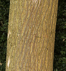
Broussonetia papyrifera – male - Trunk and bark
Fakanounou
| Fakamahino |
English: Paper Mulberry - Broussonetia papyrifera - male - Trunk and bark.
Français : Mûrier à papier - Broussonetia papyrifera - mâle - Tronc et l'écorce.
|
| Date | |
| Tupunga | Own work |
| Author | Didier Descouens |
| Permission (Reusing this file) |
I, the copyright holder of this work, hereby publish it under the following license: This file is licensed under the Creative Commons Attribution-Share Alike 4.0 International license.
|
| Other versions |
|


| Camera location | | View this and other nearby images on: OpenStreetMap |
|---|

|
This document was made as part of the Projet Phoebus.
|

|
This image has been assessed under the valued image criteria and is considered the most valued image on Commons within the scope: Broussonetia papyrifera (Paper Mulberry) trunk and bark. You can see its nomination here. |
Hisitōlia ʻo e faile
Lomiʻi ha ʻaho/taimi ki he vakai ʻo e faile naʻe ʻi ai he taimi ko iá.
| ʻAho/Taimi | ʻAtasiʻi | Hono lahi | ʻEtita | Fakamatala | |
|---|---|---|---|---|---|
| taka | 09:43, 25 ʻAokosi 2014 | | 4,573 × 4,912 (18.3 MB) | Archaeodontosaurus | {{Information |Description ={{en|1=c}} |Source ={{own}} |Author =Archaeodontosaurus |Date = |Permission = |other_versions = }} |
Faitā fehokotaki
ʻOku fehokotaki ʻa e ngaahi peesi ki he failé ni:
Global file usage
The following other wikis use this file:
- Usage on ar.wikipedia.org
- Usage on ca.wikipedia.org
- Usage on de.wikipedia.org
- Usage on en.wikipedia.org
- Usage on fr.wikipedia.org
- Usage on it.wikipedia.org
- Usage on ja.wikipedia.org
- Usage on mi.wikipedia.org
- Usage on ml.wikipedia.org
- Usage on th.wikipedia.org
- Usage on tl.wikipedia.org
- Usage on tr.wikipedia.org
- Usage on uk.wikipedia.org
- Usage on vi.wikipedia.org
- Usage on war.wikipedia.org
- Usage on zh.wikipedia.org