
File:Uruguay fisico.png

Size of this preview: 471 × 599 pixels. Other resolutions: 188 × 240 pixels | 377 × 480 pixels | 603 × 768 pixels | 1,100 × 1,400 pixels.
ʻAsi ʻa e faitā auiiki ((1,100 × 1,400 meʻaʻata, ko e faile hono lahi: 209 KB, faʻahinga MIME: image/png))

|
This map image could be re-created using vector graphics as an SVG file. This has several advantages; see Commons:Media for cleanup for more information. If an SVG form of this image is available, please upload it and afterwards replace this template with
{{vector version available|new image name}}.
It is recommended to name the SVG file “Uruguay fisico.svg”—then the template Vector version available (or Vva) does not need the new image name parameter. |
Fakanounou
| Fakamahino |
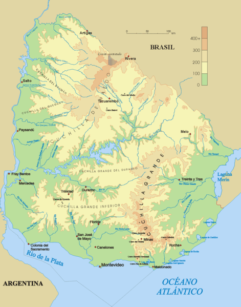
Español: Mapa físico de Uruguay.
English: Topographical map of Uruguay |
| Date | |
| Tupunga | Own work |
| Author | Jordevi |
| Other versions |
|

Laiseni:
| I, the copyright holder of this work, release this work into the public domain. This applies worldwide. In some countries this may not be legally possible; if so: I grant anyone the right to use this work for any purpose, without any conditions, unless such conditions are required by law. |
Hisitōlia ʻo e faile
Lomiʻi ha ʻaho/taimi ki he vakai ʻo e faile naʻe ʻi ai he taimi ko iá.
| ʻAho/Taimi | ʻAtasiʻi | Hono lahi | ʻEtita | Fakamatala | |
|---|---|---|---|---|---|
| taka | 03:48, 28 Tisema 2006 | | 1,100 × 1,400 (209 KB) | Jordevi | Mapa físico de Uruguay. Category:Maps of Uruguay |
Faitā fehokotaki
ʻOku fehokotaki ʻa e ngaahi peesi ki he failé ni:
Global file usage
The following other wikis use this file:
- Usage on an.wikipedia.org
- Usage on arz.wikipedia.org
- Usage on ast.wikipedia.org
- Usage on bg.wikipedia.org
- Usage on ca.wikipedia.org
- Usage on ceb.wikipedia.org
- Usage on cs.wikipedia.org
- Usage on de.wikipedia.org
- Cuchilla de Haedo
- Cuchilla Grande
- Río Negro (Uruguay)
- Sierra Carapé
- Río Yí
- Río Tacuarembó
- Río Arapey
- Río Daymán
- Rio Quaraí
- Río Queguay
- Río Queguay Chico
- Río San Salvador
- Río Rosario
- Río Tacuarí
- Río San Juan (Uruguay)
- Río Cebollatí
- Río Arapey Chico
- Rio Jaguarão
- Río San José
- Sierra de las Ánimas
- Arroyo de la India
- Río Olimar
- Río Santa Lucía (Uruguay)
- Arroyo Grande (Río Negro, rechtsseitig)
- Benutzer:Gniesgnatz/baustelle
- Usage on en.wikipedia.org
- Usage on es.wikipedia.org
View more global usage of this file.