
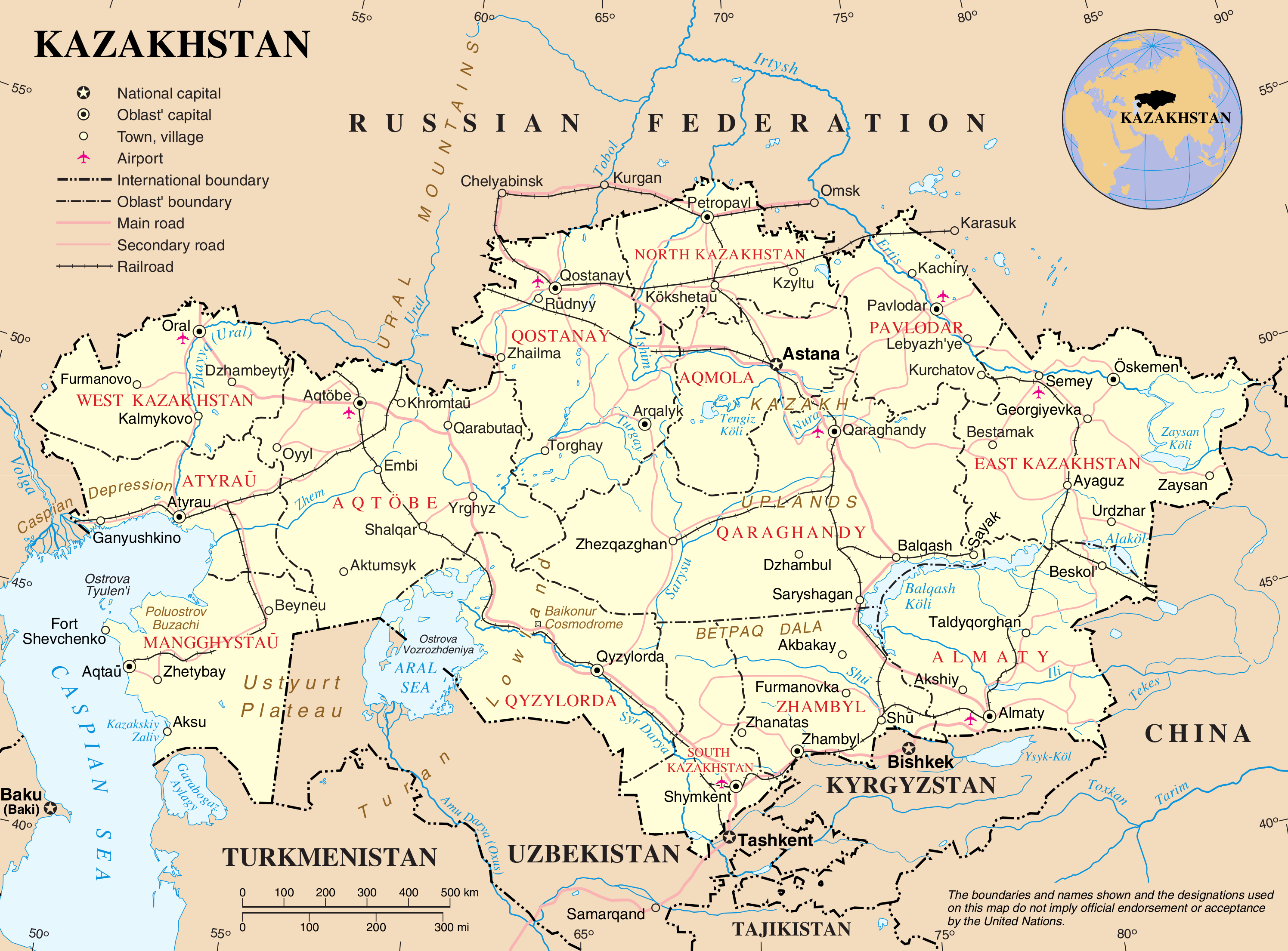
File:Un-kazakhstan.png
ʻAsi ʻa e faitā auiiki ((2,992 × 2,211 meʻaʻata, ko e faile hono lahi: 1.33 MB, faʻahinga MIME: image/png))

|
File:Un-Kazakhstan.svg is a vector version of this file. It should be used in place of this PNG file when not inferior.
File:Un-kazakhstan.png → File:Un-Kazakhstan.svg
For more information, see Help:SVG. |
 |
| This image is a map derived from a United Nations map.
Unless stated otherwise, UN maps are to be considered in the public domain. This applies worldwide. UN maps are, in principle, open source material and you can use them in your work or for making your own map. UN requests however that you delete the UN name, logo and reference number upon any modification to the map. Content of your map will be your responsibility. You can state in your publication, if you wish, something like: based on UN map … (map name, map number, revision number and date). See: Geospatial Information Section. And: Geospatial, location data for a better world. |
 |
Hisitōlia ʻo e faile
Lomiʻi ha ʻaho/taimi ki he vakai ʻo e faile naʻe ʻi ai he taimi ko iá.
| ʻAho/Taimi | ʻAtasiʻi | Hono lahi | ʻEtita | Fakamatala | |
|---|---|---|---|---|---|
| taka | 16:13, 8 ʻEpeleli 2013 | | 2,992 × 2,211 (1.33 MB) | Ras67 | cropped and optimized |
| 01:16, 24 ʻOkatopa 2007 |  | 3,038 × 2,257 (1.77 MB) | Jeroen | {{UN map}} Category:Maps of Kazakhstan |
Faitā fehokotaki
ʻOku ʻikai ha ngaahi peesi fehokotaki ki he faitā ni.
Global file usage
The following other wikis use this file:
- Usage on arz.wikipedia.org
- Usage on el.wikipedia.org
- Usage on en.wikipedia.org
- Usage on es.wikipedia.org
- Usage on fa.wikipedia.org
- Usage on fr.wikipedia.org
- Usage on it.wikipedia.org
- Usage on kk.wikipedia.org
- Usage on lb.wikipedia.org
- Usage on mr.wikipedia.org
- Usage on nl.wikipedia.org
- Usage on pl.wiktionary.org
- Usage on tl.wikipedia.org
- Usage on ur.wikipedia.org